Unlocking the future of the Automotive Industry (Part 2): Implementing Scalable Geospatial Analytics & AI
Driving Automotive and Mobility Innovation: Moving from Theory to Application with Real Time Geospatial Data, AI, and Scalable Analytics
by Eumar Assis, Fareed Aref, Varun Mahajan, Andres Urrutia, Himanshu Gupta, Michael Johns and Zachary Ryan
- Databricks allows you to serve applications and use cases related to geospatial data, including ingestions, transformation, serving, and consumption.
- In developing a complete application, Unity Catalog provides secure, governed, and shareable management of geocoding; AutoML enables rapid creation of machine learning models; and Databricks Labs Data Generator facilitates the generation of synthetic data for testing and validation
- Databricks presents a unified platform for each step required to develop these use cases at scale, with more features and benefits planned in the product roadmap.
In Part 1, we explored core concepts and datasets driving geospatial analytics in the automotive industry. In Part 2, we’ll dive into practical steps for building scalable geospatial pipelines using AI, ML, and synthetic data—while maintaining governance and performance on Databricks.
We’ll focus on real code and architecture patterns that bring these ideas to life in production-ready automotive and mobility solutions.
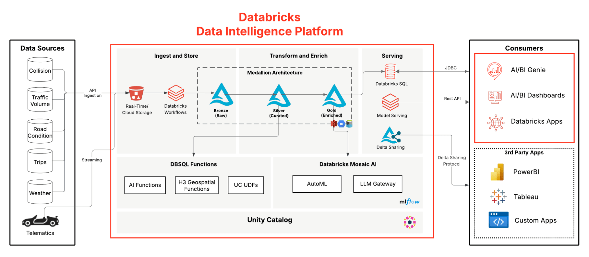
Delivering Scalable Geospatial Analytics
The Databricks’ Data Intelligence Platform combines powerful geospatial analytics and AI to deliver scalable, real-time insights. With features like Liquid Clustering and H3 spatial indexing, it enables fast and efficient processing of massive geospatial datasets. Built-in geospatial functions simplify spatial tasks such as mapping traffic patterns or assessing road risk. AutoML accelerates model development for use cases like predicting aggressive driving by factoring in weather, traffic, and road conditions. The platform also ensures strong governance through Unity Catalog (UC), which manages data access and sharing securely. Tools like AI Query and UC-governed functions make it easy to extract structured geolocation data from unstructured sources.
Build Robust Geospatial Pipeline for Smart Mobility & Road Safety
This post will focus on a full geospatial analytics pipeline built on the Databricks Data Intelligence Platform. Below we illustrate the medallion pipeline combining geospatial data, LLMs, and Genie for conversational insights.
Scalable Ingestion
Geospatial data ingestion at scale in Databricks is seamless thanks to the platform integration with a wide range of geospatial libraries and tools. Databricks geospatial functions are specifically designed to enhance spatial data handling. Auto Loader is the go-to option to process billions of files from cloud storage, while synthetic data generation can serve as an alternative during development.
Create Synthetic Telematics Data
Telematics is a strong use case for synthetic data because it enables realistic testing and model development without exposing sensitive or personal vehicle information. While synthetic data can be built using any SQL or Python logic depending on a developer’s creativity, the Databricks Labs Data Generator (dbldatagen) library makes this process significantly easier. It provides a declarative interface for creating large, scalable synthetic datasets directly on Spark.
In the example below, we use dbldatagen to simulate 1 million rows of telematics data. This setup enables developers to generate realistic datasets for modeling and testing without relying on production data.
Transformation & Enrichment
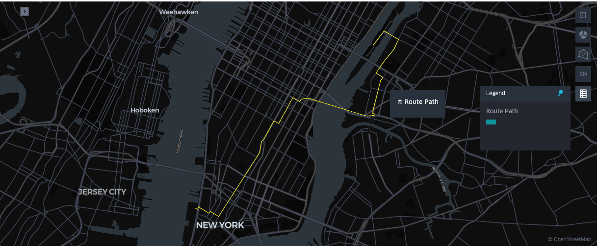
Generate Routes to Aid Analytics and Modeling
Route generation enables optimized mobility, safety, and infrastructure planning by identifying efficient, risk-aware paths from geospatial data. In our pipeline, we reconstruct routes between pickup and drop-off points to correlate paths with external factors and gain deeper insight.
In Databricks, developers can use osmnx and networkx—open-source libraries that access OpenStreetMap data and compute optimal paths across street networks. The example below uses these tools with applyInPandas to parallelize routing across Spark executors. We also offer a Solution Accelerator for scalable route generation using an OSRM-equipped Databricks cluster.
Note that this sample code requires a cluster in Dedicated Access Model as we're using sparkContext.broadcast to improve performance by not having to download graph files in each worker executor.
Build Insights with LLMs
Databricks simplifies geocoding by using a large language model (LLM) to convert unstructured text—like ZIP codes—into structured geospatial data. With a natural language prompt, the ai_query function calls the databricks-meta-llama-3-70b-instruct endpoint to generate latitude and longitude, without relying on external APIs.
While traditional geocoding tools are recommended to deliver deterministic results, this example shows how easy LLMs enhance geospatial workflows and democratize location intelligence.
Serving
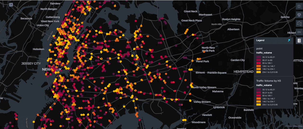
Deliver Efficient Geospatial Data Indexing
Geospatial workloads demand flexible indexing to support varied query patterns. Databricks integrates H3 spatial indexing with Liquid Clustering to efficiently handle analytical queries and model training workflows. This combination enables fast filtering on spatial data combined with other attributes—like speed or social determinants—without requiring explicit Z-ordering.
The example below shows how to leverage built-in H3 support with Liquid Clustering. It uses ST_Centroid to compute geometry center points and ST_Transform to convert them to WGS84 coordinates. Then, h3_longlatash3 generates H3 indexes at resolution 9, enabling fast, consistent spatial queries across a hexagonal grid.
The MERGE INTO operation enables idempotent upserts into silver Delta tables—preventing duplicates when processing the same data multiple times. Combined with CLUSTER BY h3_index, records are colocated based on spatial proximity. Unlike static ZORDER, Liquid Clustering supports dynamic clustering on H3 indexes and fields like timestamps or vehicle metrics without requiring predefined query patterns. This results in faster lookups, efficient filtering, and scalable model training. For more details, refer to Databricks H3 functions and Liquid Clustering documentation.
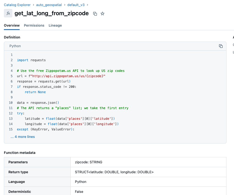
Govern Custom Logic with Unity Catalog UDFs
User-defined functions (UDFs) in Unity Catalog offer a secure, governed, and shareable way to perform deterministic geocoding at scale. By centralizing logic—such as converting ZIP codes into latitude and longitude—ensures logic and results remain consistent and auditable across users and workloads. The code below defines a Python-based UDF in Unity Catalog that securely returns the latitude and longitude for a given U.S. ZIP code using a public API.
Consumption
Predict Traffic Volume with AutoML and Time Series.
Understanding traffic patterns and risky driving behaviors is critical for smarter, safer mobility. With Databricks AutoML and spatial indexing, teams can build time-aware models without deep ML expertise.
The example below uses automl.forecast to train a time series model on traffic volume (vol) for a specific location (defined by h3_index). By focusing on a single H3 cell, the model captures temporal trends in that area. AutoML handles feature engineering, model tuning, and training—streamlining forecasting for use cases like congestion prediction and aggressive driving detection across zones.
By pairing geospatial intelligence with AI and real-time processing, automotive organizations can unlock a new level of safety, efficiency, and innovation. From predictive maintenance to smart mobility and EV optimization, Databricks offers the unified platform needed to operationalize these use cases at scale. Customers are unlocking significant value today with our H3 geospatial functions, with much more planned on the product roadmap.
Ready to accelerate your automotive geospatial journey? Explore our Geospatial Solution Accelerators, and try it out in your own workspace today.
Get the latest posts in your inbox
Subscribe to our blog and get the latest posts delivered to your inbox.